


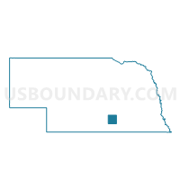
Ayr Precinct, Adams County, Nebraska
About
Outline

Summary
| Unique Area Identifier | 612413 |
| Name | Ayr Precinct |
| County | Adams County |
| State | Nebraska |
| Area (square miles) | 72.19 |
| Land Area (square miles) | 72.14 |
| Water Area (square miles) | 0.04 |
| % of Land Area | 99.94 |
| % of Water Area | 0.06 |
| Latitude of the Internal Point | 40.43681380 |
| Longtitude of the Internal Point | -98.43960210 |
Maps

Graphs
Select a template below for downloading or customizing gragh for Ayr Precinct, Adams County, Nebraska


Neighbors
Neighoring Voting District (by Name) Neighboring Voting District on the Map
- Blaine Precinct, Adams County, NE
- Blue Hill Precinct, Webster County, NE
- Denver Precinct, Adams County, NE
- Juniata Precinct, Adams County, NE
- Pauline Precinct, Adams County, NE
- Roseland Precinct, Adams County, NE
Top 10 Neighboring County Subdivision (by Population) Neighboring County Subdivision on the Map
- Juniata township, Adams County, NE (999)
- Denver township, Adams County, NE (958)
- District 2, Webster County, NE (737)
- Blaine township, Adams County, NE (497)
- Roseland township, Adams County, NE (424)
- Ayr township, Adams County, NE (413)
- Zero township, Adams County, NE (252)
- Hanover township, Adams County, NE (199)
- Little Blue township, Adams County, NE (193)
- Silver Lake township, Adams County, NE (96)
Top 10 Neighboring Place (by Population) Neighboring Place on the Map
Top 10 Neighboring Unified School District (by Population) Neighboring Unified School District on the Map
- Adams Central Public Schools, NE (5,278)
- Blue Hill Public Schools, NE (1,618)
- Silver Lake Public Schools, NE (1,446)
Top 10 Neighboring State Legislative District Upper Chamber (by Population) Neighboring State Legislative District Upper Chamber on the Map
Top 10 Neighboring 111th Congressional District (by Population) Neighboring 111th Congressional District on the Map
Top 10 Neighboring Census Tract (by Population) Neighboring Census Tract on the Map
Top 10 Neighboring 5-Digit ZIP Code Tabulation Area (by Population) Neighboring 5-Digit ZIP Code Tabulation Area on the Map
- 68901, NE (26,354)
- 68955, NE (2,025)
- 68930, NE (1,461)
- 68941, NE (832)
- 68925, NE (474)
- 68973, NE (463)